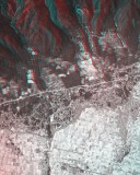
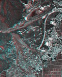
Here are anaglyphs of some interesting topography in Japan. As teaching / studying materials for geography, you can freely download them, but use for other purpose except education is prohibited.
|
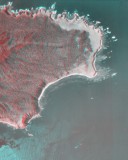
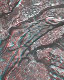
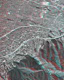
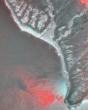
Shiretoko Cape
- Topic on Topography:
- Coastal Terrace, Coastal Cliff
- Notes:
- Shiretoko Peninsula has been inscribed on the World Heritage list as a natural property.
|
|
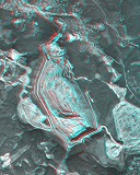
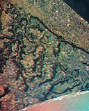
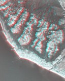
Hachinohe Canyon (Open-cut pit of limestone)
- Topic on Topography:
- Open-cut pit of limestone
- Notes:
- Hachinohe limeston mine operated by the Sumimetal Mining Co., Ltd.
- The depth of the pit is about 240m (-135m below sea level). It is called "Hechinohe Canyon".
|
|
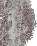
Iwate Prefecture
- Topic on Topography:
- Rias Coast, KITAKAMI Highland, OHU Mountains
|
|
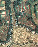
River Terrace in Numata (1)
- Topic on Topography:
- River Terrace, Alluvial Fan at Volcanic Foot
- Other Notes:
- See also River Terrace in Numata (2) adjacent to this area.
|
|
River Terrace in Numata (2)
- Topic on Topography:
- River Terrace, Alluvial Fan at Volcanic Foot
- Other Notes:
- See also River Terrace in Numata (1) adjacent to this area.
|
|
Byobugaura
- Topic on Topography:
- Pleistocene Upland, Coastal Cliff
|
|
Shimosa Upland
- Topic on Topography:
- Pleistocene Upland, Alluvial Lowland
|
|
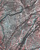
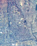
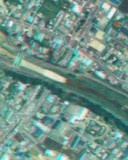
Tokyo
- Topic on Topography:
- Pleistocene Upland, Alluvial Lowland
|
|
Alluvial Fan along R. Kyodo
- Topic on Topography:
- Alluvial Fan, River Terrace
|
|
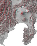
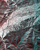
Shizuoka Prefecture
- Topic on Topography:
- Mt. Fuji, Izu Peninsula, Akaishi Mountains
|

|
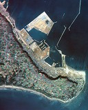
Heda and Ita
- Topic on Topography:
- Spit, Bar, Lagoon, Coastal Cliff
|
|
Makinohara Upland
- Topic on Topography:
- Pleistocene Upland (Elevated Fan), Coastal Terrace, Incised Meander
|
|
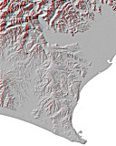
Cape Omaezaki
- Topic on Topography:
- Coastal Terrace
|
|
Iwatahara Upland
- Topic on Topography:
- Pleistocene Upland, Alluvial Lowland, Former River Course
|
|
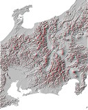
Chubu region
|
|
Alluvial Fans at the eastern foot of Yoro Mountains
- Topic on Topography:
- Alluvial Fan, Raised Bed River, Alluvial Plain
|
|
Alluvial Fan along R. Momose
- Topic on Topography:
- Alluvial Fan, Raised Bed River
|
|
Kusatsu River (1)
- Topic on Topography:
- Raised Bed River
- Notes:
- See also Kusatsu River (2), that is picked from this area.
|

|
Kusatsu River (2)
- Topic on Topography:
- Raised Bed River
- Notes:
- See also Kusatsu River (1), that covers an wide area including this area.
|
|
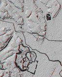
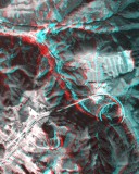
Miinohara (a pass in the Chugoku Mountains)
- Topic on Topography:
- River Capture
- Notes:
- Route 314 draws a sprial and the railway (JR Kisuki Line) has switchbacks here.
|
|
Akiyoshidai Plateau
- Topic on Topography:
- Karst landform
|
|
Ishizuchi Fault (Median Tectonic Line)
- Topic on Topography:
- Active Fault
|
|
Coastal Terrace in Muroto (1)
- Topic on Topography:
- Coastal Terrace, Vally Bottom Plain
- Notes:
- See also Coastal Terrace in Muroto (2), that is picked from this area.
|
|
Coastal Terrace in Muroto (2)
- Topic on Topography:
- Coastal Terrace, Vally Bottom Plain
- Notes:
- See also Coastal Terrace in Muroto (1), that covers an wide area including this area.
|
|
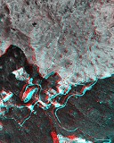
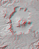
Aso Caldera
- Topic on Topography:
- Volcano, Caldera, Central Cone, Pyroclastic Flow Plateau
|
 You need red-blue (red-cyan) glasses to see anaglyph images.
