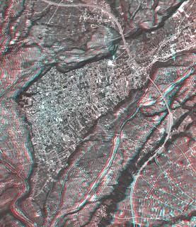
River Terrace in Numata (1)
Aerial Photograph (Anaglyph)
- 539x622pixels; JPEG; 157KB
- 1124x1296pixels; JPEG; 573KB
- 2247x2592pixels; JPEG; 1.70MB
- 2247x2592pixels; TIFF; 11.1MB
- 3024x3488pixels; TIFF; 19.1MB
Corresponding Map
- 1:25,000 Topographic Map; 72ppi; 557x622pixels; JPEG; 230KB
- 1:25,000 Topographic Map; 150ppi; 1160x1296pixels; JPEG; 968KB
- 1:25,000 Topographic Map; 300ppi; 2320x2592pixels; JPEG; 3.16MB
- 1:25,000 Topographic Map; 300ppi; 2320x2592pixels; TIFF; 12.6MB
- 1:25,000 Topographic Map; 600ppi; 4640x5184pixels; TIFF; 40.6MB
- 1:50,000 Topographic Map; 150ppi; 580x648pixels; JPEG; 264KB
- 1:50,000 Topographic Map; 300ppi; 1160x1296pixels; JPEG; 902KB
- 1:50,000 Topographic Map; 300ppi; 1160x1296pixels; TIFF; 3.50MB
- 1:50,000 Topographic Map; 600ppi; 2320x2592pixels; TIFF; 11.4MB
Laid-out sheet for print (Aerial Photograph and Map)
Notes
- Aerial Photograph:
- KT-85-1Y C5-4,5 by GSI (October 1985)
- Map:
- 1:25,000 Topographic Map "Numata" by GSI (October 1999)
- 1:50,000 Topographic Map "Numata" by GSI (March 2003)
- Location:
- Numata-shi and Showa-nura, Gunma, Central Honshu
- Topic on Topography:
- River Terrace
- Other Notes:
- See also River Terrace in Numata (2) adjacent to this area.
 You need red-blue (red-cyan) glasses to see anaglyph images.
