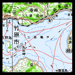
Submarine Topography in 1963
(Source: Chart published in 1963)
Submarine Topography in 1998
(Source: Chart revised in 1998)

(Click the image to enlarge it.)

(Click the image to enlarge it.)
|
Submarine Topography in 1963
(Source: Chart published in 1963)
|
=> |
Submarine Topography in 1998
(Source: Chart revised in 1998)
|
|
(Click the image to enlarge it.) |
(Click the image to enlarge it.) |
 You need red-blue (red-cyan) glasses to see anaglyph images.
For your eyes, please do not continue to look at anaglyph for long time.
 from "Digital Map 200000 (Map Image) NIPPON-III" by GSI |
See "Submarine Topography around Mihara-Seto, Seto Inland Sea, Japan".