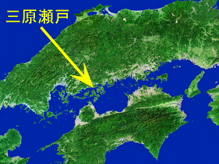
Location Map
Mihara-Seto is located in central Seto Inland Sea, western Japan.
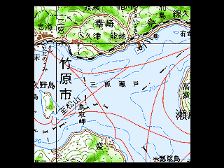
Study Area
We took up 7.7 kilometers square as the study area.
Image from "Digital Map 200000 (Map Image) NIPPON-III" by GSI
In the Mihara-Seto (Mihara Straits), a part of Seto Inand Sea, Japan, along the coast of Saizaki district in Takehara-shi, Hiroshima, the sand on the seabed has been exploited for construction material for several decades. Recently, it was found out that the illegal exploitation exceeding the permitted amount and area has been carried out. And the destruction of the marine environment is pointed out.
We tried to visualize the submarine topography by GIS so that people see the change of the submarine topography by sand exploitation.
|
Location Map
Mihara-Seto is located in central Seto Inland Sea, western Japan.
|
Study Area
We took up 7.7 kilometers square as the study area.
Image from "Digital Map 200000 (Map Image) NIPPON-III" by GSI
|
|
Submarine Topography in 1963
(Source: Chart published in 1963)
|
Submarine Topography in 1998
(Source: Chart revised in 1998)
|
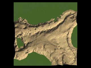 (Lighted from North-West) |
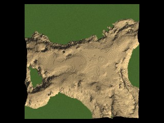 (Lighted from North-West) |
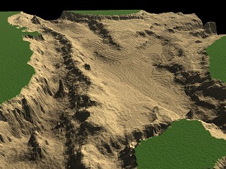 (View from West, Lighted from South-East) |
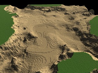 (View from West, Lighted from South-East) |
| Panoramic View RealVideo (require RealPlayer) |
Panoramic View RealVideo (require RealPlayer) |
Our reporting paper was printed in 'Chiri' vol.44 no.1 in January, 1999, and we also reported this study at the 2nd Virtual Conference of the GIS Association in Japan in April, 1999.